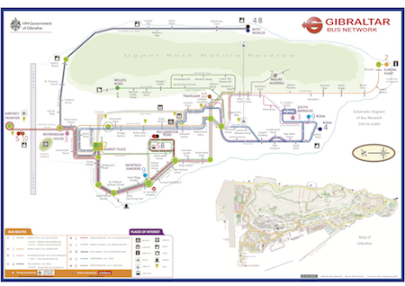
Following the launch of the redesigned new bus-stop flagpole signage in January 2019, a new bus network map has been released as part of the plan to improve the public transport offering.
The new bus network map is a schematic diagram (not to scale) displaying all bus routes, including those privately run services, namely routes 5 and 10. These network maps will feature on all bus stops that have shelters and will clearly show termini and hubs where users may change between routes. The route colour codes and bus stop names reflect those featured in all other bus related material and literature including the information within the Gibraltar Bus Company website, the Bus Tracker and the information displayed within the flagpole signage. The map also provides additional information, such as popular tourist hotspots and places of interest, which will help guide visitors and users alike and will show the bus stop located closest to the intended destination.
Our unique bus routes, as a result of Gibraltar’s convoluted road network and topography and indeed the unique needs of bus users has meant that the design of this bus network map has been a very challenging yet rewarding project to oversee.
The map can be found on all bus shelters and on the Gibraltar Bus Company Ltd website:
http://www.gibraltarbuscompany.gi/site/
The Minister with responsibility for Public Transport, the Hon. Paul Balban said, “I am very happy to be in a position to announce the launch of this bus network map for Gibraltar that will bring a much needed service improvement to visitors and local users alike. I would like to extend my gratitude to a person who has been instrumental in assisting the Ministry with this project, a very keen public transport enthusiast and a man of many talents, Dr Vijay Kumar who has worked very closely with our Transport Planner on this project.”